

Home | All About Niagara | The Geography of Niagara
The Niagara Watershed
The Niagara Region is best known for it's famous cataract at Niagara Falls, where the Niagara River drops 167 ft. on it's journey from Lake Erie to Lake Ontario. The Niagara Region is also home to many more rivers and streams, some flowing into Lake Ontario, while others flow into Lake Erie.
When the first settlers arrived in the late 1700's they quickly harnessed the power of these numerous rivers and streams. Sawmills and gristmills often determined the location of villages and towns.
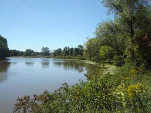
The rivers and streams today have been changed by man. With he construction of the first Welland Canal, alternate sources of water were needed, and several rivers and streams were effected. The entire area around Decew and Beaverdams was changed and Lake Gibson, a man-made lake was formed.
When the first Welland Canal was built in 1829 it followed the course of the 12 Mile Creek. When the fourth Welland Canal was built the location was moved to the east and followed the course of the 10 Mile Creek.

All the creeks flowing into Lake Ontario are named according to the distance from the Niagara River. The Four Mile Creek that flows through Virgil and St. David's would be four miles from the Niagara River, while the Forty, as Grimsby was referred to in the early days was forty miles from the Niagara River.
Today Canadians use the metric system, but in the early days of settlement the measurement of distance would be in miles, not kilometres. This system was an ingenious way of easily identifying all the numerous creeks that flowed into Lake Ontario.
Welland River (Chippawa Creek) - drains into Niagara River - 142 kms in length - In the 1920's, the mouth of the river was altered at the Village of Chippawa, diverting it's natural flow away from the Niagara River to the power generating stations.
Now the waters from the Niagara River flow backward up the mouth to the Welland River and into the hydo canal for power generation.
The Welland River was an early transportation route for the First Nations and the earliest settlers. Long before roads were built into the interior, settlers used the Welland River as a means of transporting people and goods to the forts at Niagara.
Beaver Creek - drains into Welland River
Black Ash Creek - drains into Welland River
Sucker Creek - drains into Welland River
Drapers Creek - drains into Welland River
Little Forks Creek - drains into Welland River
Coyle Creek - drains into Welland River
Ussher's Creek - drains into the Niagara River
Bayers Creek - drains into Niagara River
Beaverdams Creek - drains into Lake Gibson
Shriner's Creek - drains into Welland Canal
Lyon's Creek - drains into Welland River
Tee Creek - drains into Welland River
One Mile Creek - drains into Lake Ontario
Four Mile Creek - drains into Lake Ontario
Eight Mile Creek- drains into Lake Ontario
Ten Mile Creek - drains into Welland Canal/Lake Ontario
Twelve Mile Creek - drains into Lake Ontario
Fifteen Mile Creek - drains into Lake Ontario
Sixteen Mile Creek - drains into Lake Ontario
Eighteen Mile Creek - drains into Lake Ontario
Twenty Mile Creek - drains into Lake Ontario
Thirty Mile Creek - drains into Lake Ontario
Forty Mile Creek - drains into Lake Ontario
Walker's Creek - drains into Lake Ontario
Spring Creek - drains into the Twenty Mile Creek
Beaver Creek - drains into Lake Erie
Black Creek - drains into Lake Erie
Baker Creek - drains into Lake Erie
Frenchman's Creek - drains into Lake Erie
Six Mile Creek - drains into Lake Erie
Beaver Dam Creek - drains into Lake Erie
Oil Mill Creek - drains into Lake Erie
Wignell Creek - drains into Lake Erie
Wainfleet Marsh - drains into Lake Erie
Richardson Creek - drains into Martindale Pond
Francis Creek - Dick's Creek - drains into old welland canal/Twelve Mile Creek